A Virtual Hike in the Grand Canyon
Down the South Kaibab Trail and Up the Bright Angel Trail
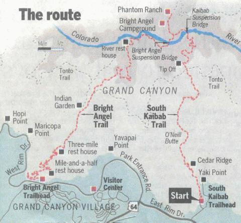 |
The map above was taken from an excellent article in the Arizona Republic, "From Couch to Canyon" shows my exact route starting down the South Kaibab to the Colorado River, onto Phantom Ranch, and then returning to the rim via the Bright Angel. The total distance for this hike is 16.7 miles! This is the most popular route to the river and back (for good reason), and always a test of endurance and a hike that always needs to be taken seriously and not done on a whim!
I've put these pictures together in the hopes of providing a virtual hike into the Grand Canyon since I have pictures from nearly the entire trail. Many of the pictures have additional information which you can read by hovering your mouse over the thumbnail picture. But as good a any picture might be, anyone who's been there will tell you they can't do the place justice. I'm afraid my most appreciative audience will be those who've had the privilege of hiking these spectacular trails and will get a trip down memory lane. Having said that, over the years I've received an incredible amount of email from readers using the virtual hike as part of their planning for a future hike. Never in my wildest imagination did I anticipate this, but since it is a reality, I have added more information to help would-be hikers.
| Note about the images: All the pictures are "thumbnail" images and by clicking on them you will see the full-size image. If you'd like to see all the pictures from this page in a slideshow, go to the end of the page. |
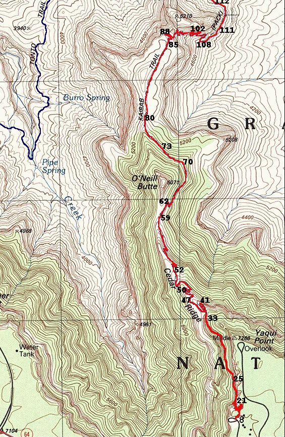
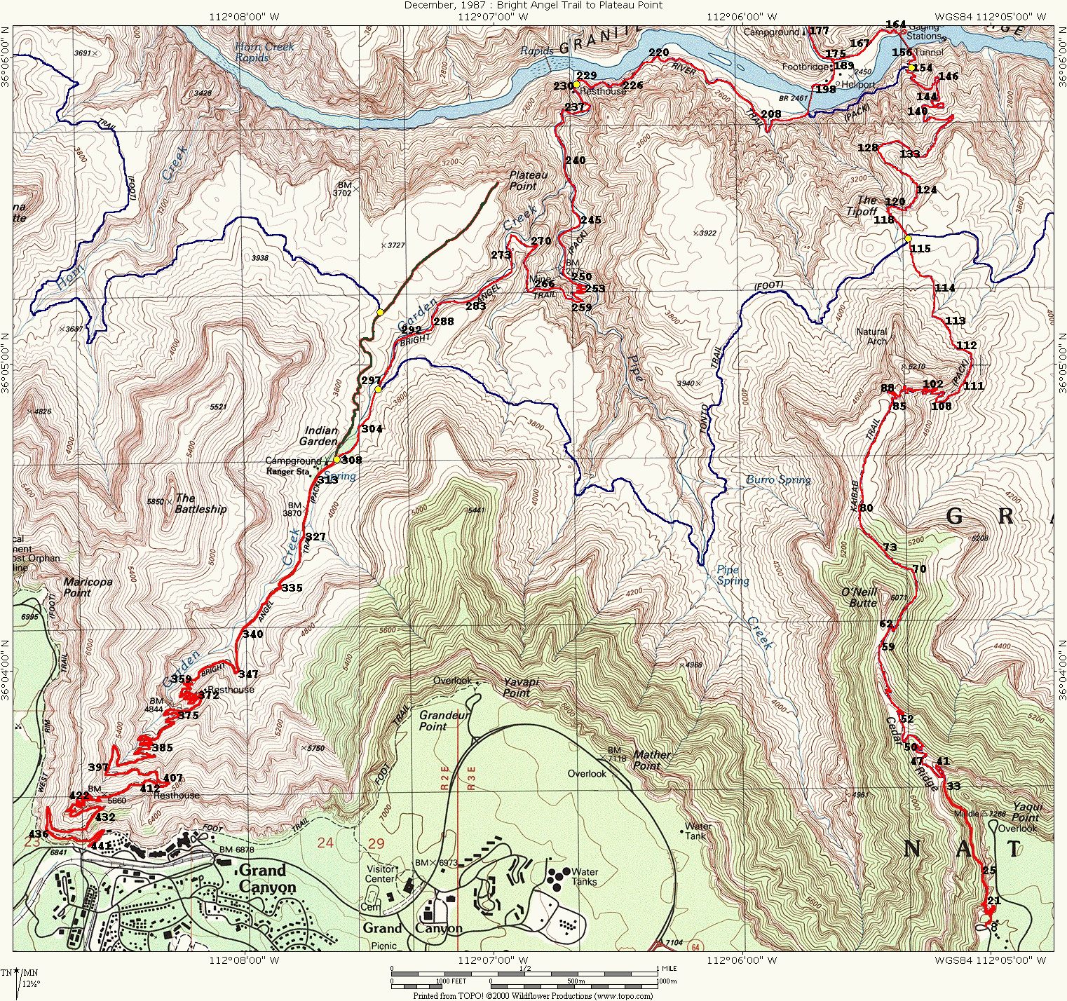
The topographical maps show a more detailed view of the route and they are numbered to show the approximate locations where the pictures were taken.
The Superhighways
 |
|
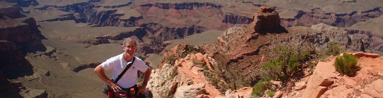
Your tour guide, Gene. |
Obligatory Disclaimer
Are you planning on visiting the Grand Canyon? Are you actually contemplating a hike into the Canyon? If so you should read the following disclaimer and some of my personal thoughts about the danger.Start down the South Kaibab Trail
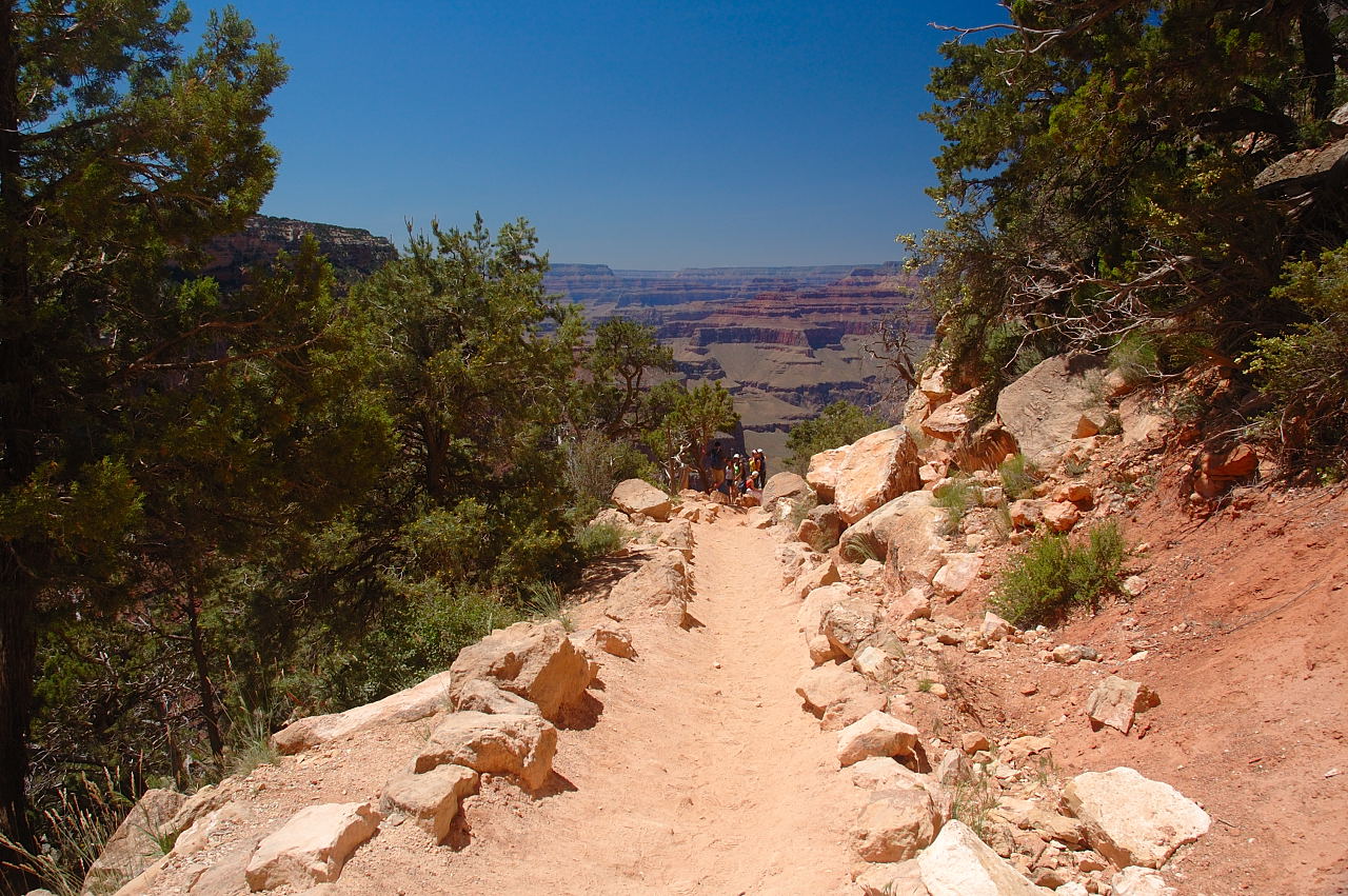
How can you describe the view from the South Kaibab Trail? If I had to level it down to one word it would be "spectacular." That's what I think when I look at these photos. When you are actually there at the canyon on the trail, however, it practically leaves you speechless. Words cannot adequately describe it. But as nice as these pictures are, even they are inadequate! They don't capture all the colors and they definitely do not purvey the magnitude of it's size. The sight, the sounds, the smell, and the feel of the trail overload your senses. Many of the pictures have further descriptions which you can read by hovering your mouse over the thumbnail image.|
|
Map 1, Pictures 1-85
The map above gives the overall route for the hike. The map at the left shows a more detailed view of the first part of the hike. I have numbered the pictures on the detail maps to indicate the locations where they were taken. Most of these locations are fairly accurate, but there are some that I must admit are just "best guesses." Click on the map to view it full size. Click here if you want to see the entire map showing the entire route with the pictures marked. 957K. |
A Note About the Pictures
The pictures for this version of the virtual hike actually come from 3 different hikes, but primarily from the 2008 hike. If you hover your mouse over the picture you'll see the picture number and many times further description. Unless otherwise indicated, the picture is taken looking in the direction of the hike (i.e., forward). If the photo is taken looking back from where I was, (Back) will be indicated, although many times that would be obvious. Also, (Right) and (Left) will designate looking in those directions.


Unless you're hiking during the winter months, the road to the South Kaibab trail head and Yaki Point is closed to vehicles. You must board a bus at the Visitor Center that leaves at 20 minute intervals. In the very early morning this bus is not generally crowded and most of the riders are doing an overnight hike. I might generally like to start earlier, but this was another picture hike and I wanted maximum sun so I'd planned for an equal 2:50 on each side of noon. Our bus was packed and it pulled into the parking lot at 9:00. There is a short path from the parking lot to the actual trail head. For me, this is when the real excitement begins. There is a mule corral to the right, but there were only a few mules to be seen. Presumably, the rest were all in the canyon. During the summer months there is a water spigot, but I would never depend on this! You should have all your water bottles filled before you board the bus.


 |

I didn't need to read the "Eat!" reminder. I know very well the importance of fueling the body. Just before departing for any canyon hike, I eat a very large breakfast.
My plan this time was a 5:45 hike and my wife would be waiting for me at the 1.5 Mile Resthouse at 2:00, exactly 5 hours into this hike.
 |
 down a series of sharp switchbacks in the nearly vertical limestone wall.
The floor of the trail is crushed limestone, but it's dotted with many droppings
from the mules and it is the wise hiker who avoids these. A first time
hiker is justly worried that dodging these obstacles will be continuous, but for
some reason the mules must have the same reaction to being at the top of the
trail and looking down in the vastness, "Oh, #$@*! We're going way
down there?" Though you share the SK and BA trails with the mules, a sign near
the start lets you know who has the right of way: "When Mules Pass Stand Quietly and Follow Mule Guides Instructions."
down a series of sharp switchbacks in the nearly vertical limestone wall.
The floor of the trail is crushed limestone, but it's dotted with many droppings
from the mules and it is the wise hiker who avoids these. A first time
hiker is justly worried that dodging these obstacles will be continuous, but for
some reason the mules must have the same reaction to being at the top of the
trail and looking down in the vastness, "Oh, #$@*! We're going way
down there?" Though you share the SK and BA trails with the mules, a sign near
the start lets you know who has the right of way: "When Mules Pass Stand Quietly and Follow Mule Guides Instructions."
During the winter months you may often have to contend with snow and ice on the trail. A hiker with a big backpack may well consider a set of crampons. The SK does get a lot of direct sun so any snow and ice does melt readily. At the top of the BA, however, there is much less sun so snow and ice can linger well into April.


 Looking back notice how virtually invisible the trail is.")

 view of the canyon.")

The switchbacks end soon and the trail now levels and the decent for the next half mile is very gradual, following the limestone wall which is immediately on your right. As you go down it is worth several looks back towards the top and you are amazed how invisible the trail is.
")


")
 The limestone wall with the opening switchbacks now completely invisible.")

 |
You might also be naively thinking if this your first hike, "This isn't all that bad! We'll be at the bottom of this trail in no time at all." The bottom is still 6 miles away! So why is the guy at the left (i.e., your tour guide) smiling? |


We are now approaching the Ooh-Ahh point of the South Kaibab. So far the trail has hugged the tall wall to the right and above this is the Yaki Point lookout. This blocks a lot of the view. The Ooh-Ahh point is where the trail takes a very sharp turn just after it clears this wall. The large boulders you see in picture 039 is the actual point.
 The \"steps\" just before the Ohh-Ahh Point.")
 Another view of the \"steps\" just before the Ooh-Ahh Point.")
") |
 of the South Kaibab because
it is visible for almost half the trail. You can always tell where you are
on the South Kaibab if you spot this landmark. From this spot you can see
a lot of the trail. This is really a fabulous section of trail from here to
Cedar Ridge. Click here to see another picture taken
from this location with the trails in the distance marked. If this is your
first time down the SK, slow things up and enjoy every minute of this view.
Besides, we're bound to be arriving at the river soon, right?
of the South Kaibab because
it is visible for almost half the trail. You can always tell where you are
on the South Kaibab if you spot this landmark. From this spot you can see
a lot of the trail. This is really a fabulous section of trail from here to
Cedar Ridge. Click here to see another picture taken
from this location with the trails in the distance marked. If this is your
first time down the SK, slow things up and enjoy every minute of this view.
Besides, we're bound to be arriving at the river soon, right?
 |


")


Cedar Ridge is a relatively flat area about 1.5 miles from the trail head and 1000 feet below. It is the recommended stopping point for a day hike on this trail. There is a rest house and there are hitching posts for the mules. I've seen Cedar Ridge crowded with people and virtually deserted. It seems to be related to the time of day. The later in the day, the more crowded it is mainly because of the day hikers. There is no water here nor anywhere else on the SK. Besides a rain shower, the only other water would be from a fellow hiker.


 Still at Cedar Ridge.")


It has been my experience that you really start to feel you're in for a long hike when you've arrived at O'Neill Butte and begin to transverse it's slopes. You've already gone a long way and the river is still no where to be seen!


")


 So why are these people just watching and not helping?")


 Looking into Pipe Canyon.")
 Looking into Pipe Canyon. Somewhere there in the distance is where we'll come up the Bright Angel Trail.")

 Looking back at O'Neill Butte")
")


 |
If you'd like a full-sized slideshow, click on any of the images which will take you to my Google site and launch a slideshow. Note: this slideshow isn't mobile-friendly. If you like to go to the Google page for the pictures, click here.
We've only just started the hike! 5 more pages to complete the entire tour. To continue on hit next.
![]()
![]()